Last summer, UNINFO – ICT technologies and applications, the standardization body federated with UNI, published the UNI 11621-1:2017 standard that establishes the general criteria for the definition of professionals working in the geographic information field by identifying their distinguishing set of knowledge, skills and competences.
At the time of publication of this standard, the maintenance, updating and evolution of the skills necessary for the professional activity of the GI professional were not the subject of any specific training and/or certification course. A professional was required to follow autonomous or guided courses of continuous professional updating to improve their profile. Moreover, the involvement of GI professionals in new and evolving scenarios, such as Sustainable Development, Digital Revolution and Smart City / Community as its paradigm, was increasing the demand for professionals with specific skills.
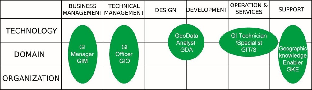
The UNI 11621-1:2017 standard was born from the awareness that it was time to define useful criteria to recognize, and possibly certify, skills and abilities in the GI sector. It derived from principles and indications of both the European e-Competence Framework (e-CF), to support the professional profiles description, and the updated version of GI Science & Technology – Body of Knowledge, as in the “Geographic information – Need to Know. Towards a more demand-driven geospatial workforce education/training system” project. In particular, the scheme adopted took into account that none of the e-CF ICT profiles fully meets the needs of each situation, in the everyday activities related to the GI. Indeed, it is common that the work of a professional requires the integration of components of different geo-ICT profiles or that a specific geo-ICT profile is divided and carried out by more professionals. Then, by applying a bottom-up approach, the competences resulting from the knowledge and skills analysis were projected and grouped in a matrix and the result led to five profiles, as shown in figure 1. The columns correspond to the six main families of ICT profiles, according to the ICT family tree established by the UNI 11621-1, and the rows coincide to the three dimensions of the “space” in which the professional GI operates.
Figure 1. Identified profiles of the GI professional
AMFM GIS Italia [www.amfm.it] collaborated in this activity, along with other Italian associations and public institutions, such as the Italian Agency for Digital Agenda (AgID) [https://www.agid.gov.it/en] and Stati Generali dell’Innovazione (SGI) [https://www.statigeneralinnovazione.it/online/english/]. The work was collaborative and cooperative, integrating different approaches, both theoretical and practical, leading to a shared view on the orientation to be taken to identify the aforementioned professionals. It is important to emphasize that the methodological approach to define the profiles can be replicable and / or scalable. That is, the described process carried out to arrive at this standard can be repeated and properly adapted to define new profiles in response to the foreseeable technological progresses and the growing demand for GI professionalism.
Professional Profiles
Five professional profiles are defined, each described in terms of Summary statement, Mission, Deliverables (Accountable, Responsible, Contributor), Main tasks, e-Competences (from e-CF), Skills and knowledge (Technical, Reference to the Knowledge Areas of GIS&T-BoK, Information Technology, Enhancement), and KPI area.
GeoData Analyst (GDA)
Expert in processes, methodologies and technologies of geospatial data acquisition and manipulation. The GDA deals with analyzing spatial data to design strategies and make decisions, to produce information and new knowledge aimed at dealing with problem solving activities. Special attention should be paid to the context of spatial “Big Data”, where the GDA has to orient among large volumes of data in order to identify, summarize and show data useful to address a problem or to simplify a complex decision.
Geographic Information Manager (GIM)
Professional position included in the governance bodies of an organization to support and manage geospatial data and technologies available for its collection, management and sharing, with special attention to the development of SDIs. The GIM facilitates the growth of the digital competences within the network that composes an organization.
Geographic Information Officer
Professional responsible for managing activities, people and overall resources of the GIS structure of an organization, as well as of the broader context relating to setting-up of Spatial Data Infrastructures (SDI).
Geographic Information Technician / Specialist (GIT/S)
Professional expert of the most common processing procedures for geographic information, such as acquisition, gathering, creation, editing and management of all datatypes (raster, vector, databases) of GIS applications, possibly starting from different data sources, (also non-spatial), map creation and customized GIS applications, presentation of numerical, graphical and cartographic results. A GIT/S supports specialists in various sectors (urban planners, analysts, geologists, etc.), public administrations and companies in the development, management, updating and use of geographic information systems even in the broader context of the SDI construction.
Geographic Knowledge Enabler (GKE)
Professional expert in spatial literacy and methodologies for the development of spatial thinking and geo-digital skills.
Work in progress
UNINFO is updating the standards on professional profiles by incorporating the updates of the European eCompetence Framework. The Italian GI experts are already reviewing the one for the Geographic Information professional profiles.
Monica Sebillo and Sergio Farruggia
(AMFM GIS Italia)